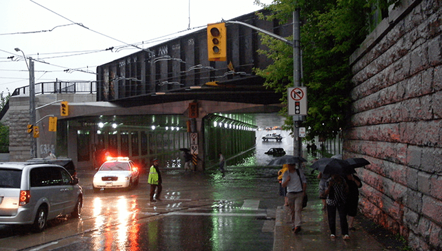
I’m sitting at home watching the late-night local news and the biggest story of the hour is the flooding of Toronto’s Don Valley Parkway after a heavy downpour of rain the evening before. “We got a lot… in fact, a month’s worth,” the weather guy explains when asked how much rain came down in a very short period. It caused the nearby Don River to jump its banks and rush onto the highway — a main artery into Toronto — resulting in drivers being stranded and leaving behind a thick layer of muck and garbage. Maybe this has happened before. I can’t remember in my lifetime, but maybe. Either way, cleaning it up comes at a cost.
Why did this happen? Could it be that Toronto simply has too much asphalt and concrete and not enough green living infrastructure? “The Don flooding is perhaps a teachable moment on this issue,” Faisal Moola, director general of Ontario and Northern Canada for the David Suzuki Foundation, wrote me in an e-mail. Moola said there are “definite links” between the flooding and the insufficient green infrastructure where it occurred, beyond the fact that the lower sections of highway and associated urban and industrial infrastructure in the area are built in a floodplain. “We could mitigate some of the worst of it if we integrated green living infrastructure technologies, as well as restored and protected existing natural areas to provide ‘natural’ flood protection,” he wrote. “This includes riparian vegetation, engineered wetlands and permeable land surfaces that collectively would regulate, store and slowly release rainwater into the main channel of the river, as opposed to what happened on the highway — huge amounts of rain simply entered into the river across built infrastructure such as roads, parking lots and homes without any mitigation at all.”
This flooding event is timely, in the sense that Moola has an article in the upcoming issue of Corporate Knights that explains in detail the huge environmental, health and economic benefits that green living infrastructure brings to cities. His piece is part of a larger section on sustainable cities, which includes a sustainability “scorecard” of North America’s 20 largest cities, as well as articles on the problem of urban sprawl, the benefits of GPS-based congestion charging, PACE programs for municipal financing of building retrofits, and why the largest cities in North America won’t look so large on the global stage over the next 50-plus years. The package is a great read, and it comes out June 6 in the Globe and Mail and limited issues of theWashington Post. (Hey, if you want to subscribe to the digital version of the mag for reading on your iPad, click here).
As for the need to “green” the areas around the Don River, the good news is that something is in the works through Waterfront Toronto, the agency created in 2001 to revitalize Toronto’s waterfront. Naturalizing the mouth of the Don River and providing flood protection to the Port Lands were identified as top priorities for all three levels of government when they first establishment Waterfront Toronto. “A naturalized Don River mouth will enhance water and land habitat for natural species and create the potential to re-establish wetlands in the area that were lost 100 years ago. The project will also create flood barriers for the Port Lands area which has been identified as one of the greatest flood risks in downtown Toronto,” according to the agency’s website.
In other words, as far as last night’s downpour is concerned, we had it coming.


